

The Original Nine.
Personally, I believe far too much of our local history has been set in stone, so to speak. A story is written down, repeated often enough and, over time, simply accepted as fact. Rarely do we stop to question where the information originally came from or whether the evidence actually supports it.
I've always been someone who goes against the grain. I don't accept history simply because it's the version we've always been told. I like to look at things differently, to question, investigate, and, at times, approach the evidence almost forensically.
When researching Charlestown's past, I believe we have to consider the evidence both logically and practically. Does the story make sense? Could it actually have happened in the way described? More importantly, what contemporary evidence exists to support it?
My research has already shown that a surprising amount of Charlestown's accepted history is questionable. Dates have been repeated incorrectly, events have been misinterpreted, and, in some cases, long-standing claims appear to have little or no evidence behind them.
So far, I have identified six or seven significant parts of Charlestown's history that I believe have been recorded incorrectly. The dating of the name change from West Polmear to Charlestown, the excavations associated with the dock, and the date clay was first piped to Charlestown are just a few examples.
For me, this isn't about rewriting history for the sake of it. It's about questioning what we've been told, returning to the original evidence and trying to get as close to the truth as possible.
After all, history should never be beyond question.
I, for one, have never completely bought into the story of just nine people living at Polmear when Charles Rashleigh bought the land in 1779. I have argued this point on my tours for the past five years.
To me, the sums simply don't add up.
On John Norden's map from the late 1500s, Polmere is clearly marked. On Thomas Martyn's map of the early 1700s, we see a lane running down from the Turnpike towards the beach.
If only a tiny handful of people lived here, why was that access needed?
Polmere was also substantial enough to receive a mention in Stephen Whatley's England's Gazetteer, Volume III, published in 1751.
Then there is one of the earliest known surviving documents relating to Polmere.
Dating from 1720, it records a watch of men on Polmere Beach and clearly lists twenty men covering the day and night watches.
So where did these men come from?
Some of the names are very familiar to Charlestown historians today: Walkey, Williams and Daniels.
"Where's your evidence?" I hear you ask.
Well, that's a valid point!
I don't yet have a document that gives us a neat and tidy answer. However, in my opinion, the accepted version of events raises more questions than it answers.

Was Polmear Really Just a Few Cottages?
Polmear appears on a much earlier map as Porth Meur.
If a settlement was important enough to be identified by name, was it really no more than a couple of tumbledown, miserable cottages, as later described by Canon Hammond?
Then we have to consider something far more basic.
Families and contraception!
My study of the early social history of the village shows households with seven, eight and sometimes ten children. Many of those same families had lost almost as many children again because infant mortality was tragically high.
There was, of course, no modern contraception.
Families could be enormous.
This brings me to perhaps the strongest documented evidence concerning the population: an article published in The Gentleman's Magazine in 1800.
It gives population figures during the initial development of the village:
1790 — 9
1791 — 26
1792 — 97
1793 — 109
1794 — 163
1795 — 175
1796 — 205
1797 — 234
1801 — 300
But how accurate are these figures?
Were they based on tenancy records? Permanent residents? Households?
The truth is, we simply don't know.
Interestingly, the west pier was built between 1791 and 1792, when the recorded population stood somewhere between twenty-six and ninety-seven people.
Think about that for a moment.
A major harbour construction project was taking place, yet the recorded population was supposedly tiny.
I think what we may actually be looking at is a permanent resident population of nine, while many more people travelled in and out of Polmear every day for work.
St Austell was only around half an hour away on foot. Labour could easily have been drawn from the surrounding area.
And once we start looking at Polmear as a workplace rather than simply a village, the picture begins to change.
Higher and Lower Polmear
On an early maritime map in my collection, two distinct clusters of buildings can be seen: Higher Polmear and Lower Polmear, the latter also known as West Polmear.
Four buildings are shown at Higher Polmear and six at West Polmear.
That is ten buildings.
Already, the picture is rather more complicated than nine people living in a couple of miserable cottages.
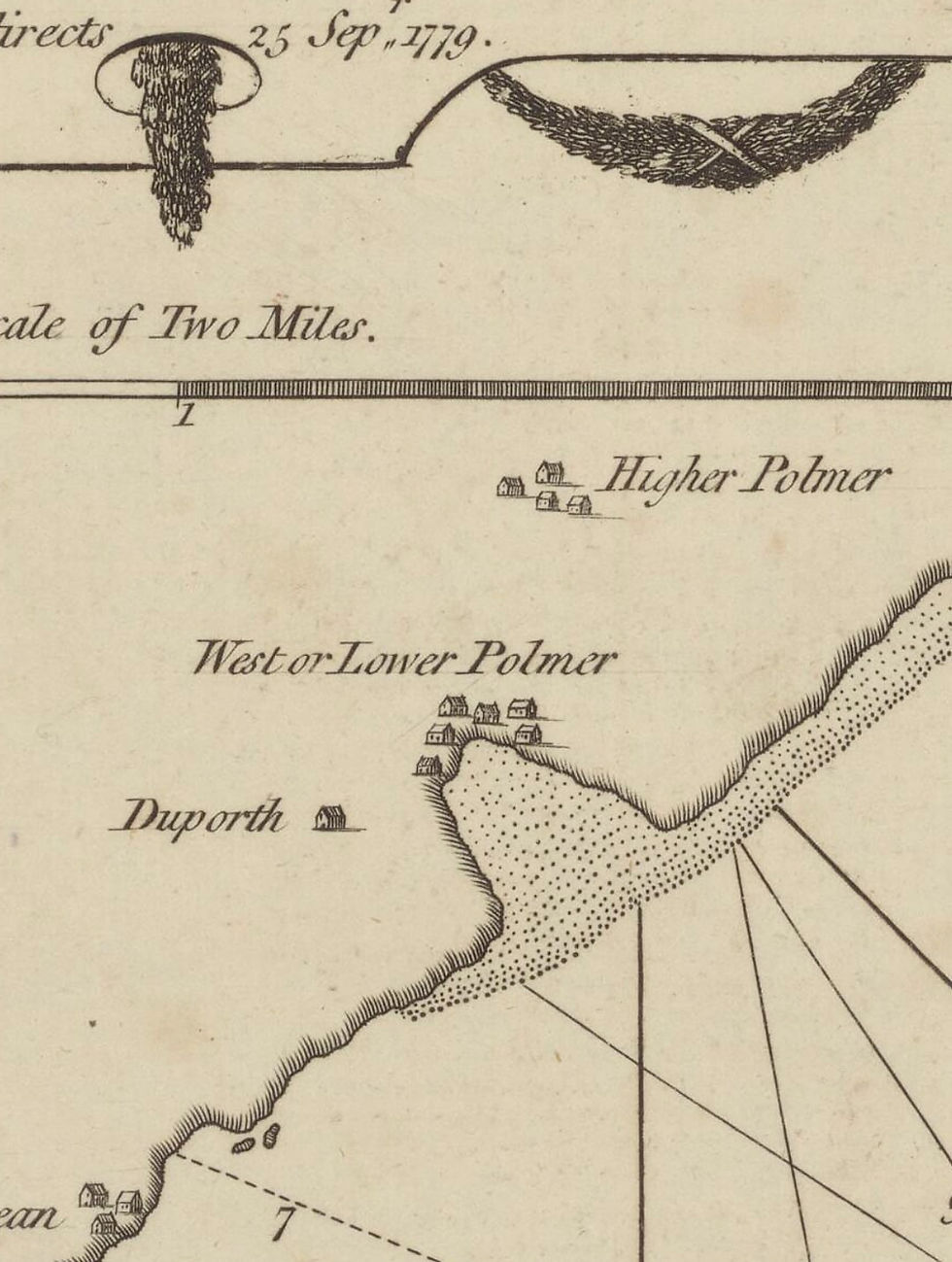
Higher Polmear
Higher Polmear appears to have been a farming settlement centred around today's Polmear Farm.
Some of the other buildings may have been granite barns and a granary. These were located near Eleven Doors. There may also have been a grain store in the building, later associated with smoked fish processing.
Interestingly, the present Polmear Farm building exhibits two very different architectural styles.
An 1830s brick-built extension is attached to a considerably older farmhouse, possibly dating to around 1780. However, it has often been stated that the farmhouse itself was built on the site of an earlier dwelling.
There is also evidence of a medieval field system to the east of the farm.
And the farm would have required labour.
We must remember that there was no mechanisation in farming at this time. Grass was cut with a scythe. Harvesting, ditching, livestock management and countless other jobs relied almost entirely on human labour.
A small family farm of perhaps twenty to eighty acres would typically have relied on two to four people: the farmer, spouse and older children, sometimes with additional labour when required.
These farms were largely concerned with feeding the family, with any surplus sold or traded locally.
So even a modest farm at Higher Polmear represents people.
And labour.
West Polmear and the Pilchard Cellars
Lower Polmear, or West Polmear, appears to have consisted of several pilchard cellars and the building now known as 21 Charlestown Road.
Number 21 was originally an ale house or Kiddlywink and dates to around 1780. Its first landlord was Thomas Martyn. Originally semi-detached, one house was taken down in 1810. I always thought that to be to the north of the cottage. However, I now think it was to the Pier House side at the southern end.
The layout on the southern side of the building, with its huge multiple cloam oven system, also suggests the possibility of a baker's premises.
Perhaps it was an inn that also baked bread.
The building's alignment does not sit comfortably with the modern dock layout either. Again, parts of the house appear to belong to an earlier dwelling.

The pilchard cellars at West Polmear included Content, Triah and, quite possibly, the earliest of them all, Union — now part of the Longstore complex.
The Cornwall Archaeological Unit, and in particular Eric Berry, suspected that some form of structure existed on the Union Cellars site, perhaps a century before Rashleigh purchased the land.
It may not have been the building we recognise today, but ground assessments discovered post-holes and a pilchard water-drain culvert which appeared to pre-date the existing site.
Then we have other documented residents.
Macklin and Emblin Tucker were timber and coal merchants and tenants of fish cellars. They held a large two-acre plot of land located roughly where today's dock now stands.
Larn mentions them in his book, and I have documents relating to them from before Rashleigh's time.
Now consider the practicalities of their business.
Could a single man have unloaded a small ketch carrying, say, twenty tons of coal?
Yes, I suppose he could — with the assistance of the ship's crew.
But it would have taken days.
And that is where the practicalities become worrying.
A vessel sitting on an open and exposed beach could not simply remain there indefinitely while one or two men leisurely unloaded twenty tons of coal.
There had to be labour available.
And this brings me to possibly the biggest clue of all.
The pilchard fishery.
The Pilchard Question
A single pilchard cellar in Cornwall around 1800 could require between twenty and fifty workers, depending on the size of the seine company and the volume of the catch.
The workforce was highly organised and divided into specialist roles.
The huers were lookouts stationed on high ground, watching for the dark mass of a pilchard shoal and directing the boats into position.
We know that the area later occupied by the Battery was used by Huers. It was a perfect vantage point from which to "hue and cry".
The fishermen, or seiners, perhaps eighteen to twenty men, handled the great seine boats and tuck nets used to surround and bring in the catch.
The cellar women, or curers, ranged from young girls to elderly women. They formed the heart of the shore-based workforce, working in busy groups and carefully layering thousands of pilchards with salt into great piles known as bulks.
Children worked as runners, carrying salt, fish and equipment between the stores and the cellar workers.
The pressmen operated the heavy wooden or pole presses. These squeezed the packed fish in hogshead barrels, extracting the valuable pilchard oil before the fish were exported.
Every hogshead held roughly 3,000 fish.
That is a lot of work.
And Polmere records seasons of 600 hogsheads.
Then there were the coopers — essential craftsmen responsible for making and maintaining the huge number of wooden hogsheads required by the industry.
Now ask yourself this.
If Polmear had three active pilchard cellars, where did all these people come from?
They certainly weren't all among the famous "original nine".

Union Cellars
I spent many hours in the Union Cellars building during the late 1980s.
The building was originally used for processing pilchards, and the press holes can still be seen in the wall.
I rented the building from around 1986 until 1989 and used it as a net-rigging shed. Before me, it had been used as a loft by local fishermen.
These men were not full-time fishermen. Fishing was largely a hobby.
When Mike Brokenshire, John Wilkins, Alan Fairless and I became full-time fishermen in the early 1980s, we were the first at Charlestown for a generation.
Similar press holes can be found at several locations around the village.
For many years, Content Cellars — now Salamander — was identified by the Cornwall Archaeological Unit as the oldest cellar and possibly the oldest surviving building in the village, dating to around 1740.
But now I have my doubts.
And, to be fair, I have proved them wrong on a few occasions in the past!

The Mystery of Triah Cellars
During my early research, I repeatedly came across another name.

Triah Cellars.
For years, I assumed Triah had simply become Content Cellars.
Then, a couple of years ago, I saw the Duporth Cup.
The cup was given to Charles Rashleigh as a token of appreciation. Around the cup and its lid are miniature painted scenes showing the construction of the outer basin.
One of those paintings caught my attention.
It shows a single building standing roughly where the west beach slipway seats are today, between the Pier House and the beach.
Most importantly, no harbour has yet been constructed in the miniature.
Then I remembered the wall above those seats.
There are numerous press holes in it.
But these holes are different.
They aren't as square or as regular as those found at Content, Union or even Friends' Endeavour.
To my eye, they look cruder.
Perhaps they are earlier versions of the near-perfect square press holes seen in later pilchard cellars.
Can I say with 100 per cent certainty that this was Triah Cellars?
No.
Not yet.
But I have a hunch.
And I'm now on a mission to find the evidence to support it.
Content Cellars eventually closed in 1833, and later the space above the cellar was converted into dwellings.

So, What Do I Think?
My theory is that Triah Cellars originally stood on the western side of the harbour, roughly where the seats are today. Possibly a lean-to building with an open front.
I believe the building may have been demolished to create access for the construction of the pier.
It would not be the first time the landscape of Charlestown has been altered far later than people assume.
Even the slipway to Coastguard Beach is more modern than many people realise.
I have photographs showing the beach with no slipway at all.
That slipway wasn't built until 1927.
So history is not always as fixed as we think.
And, just as I did with the name of West Polmear, I hope to find further evidence of Triah Cellars and eventually prove — or disprove — my theory.
And as for the "original nine"?
I don't necessarily doubt the figure.
I doubt what we have assumed it means.
Nine permanent residents may well have lived at Polmear when Rashleigh began his development.
But the maps, the farms, the coal trade, the twenty-man beach watch and, above all, the pilchard industry suggest something much busier.
I believe Polmear was not an isolated settlement of nine people.
It was a workplace.
And every day, people came and went.
Written by Lyndon Allen, July 2026.


Comments